Cunonia capensis
Selected images: Click on each image to see a larger version and details of the record View all images (3)
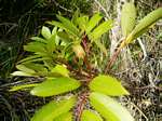
Photo: Mark Hyde
Kirstenbosch Botanic Garden, Cape Town, South Africa
Photo: Sune Holt
Kirstenbosch National Botanical Garden, S.A.
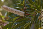
Photo: Sune Holt
Kirstenbosch National Botanical Garden, S.A.
Detailed records: Display species records QDS maps by: Google Maps Point records by Google Maps
Species details: Click on each item to see an explanation of that item (Note: opens a new window)
| Synonyms: | |
| Common names: | |
| Frequency: | |
| Status: | |
| Description: |
Shrub or tree. Leaves imparipinnate with markedly red petiole and rhachis. |
| Type location: |
|
| Notes: | A very doubtful record for Zimbabwe, based on a folder in SRGH. |
| Derivation of specific name: | capensis: of the Cape |
| Habitat: | |
| Altitude range: (metres) | |
| Flowering time: | |
| Worldwide distribution: | |
| FZ divisions: | E |
| Growth form(s): | |
| Endemic status: | |
| Red data list status: | |
| Insects associated with this species: | |
| Spot characters: | Display spot characters for this species |
| Images last updated: | Saturday 19 September 2015 |
| Literature: |
Other sources of information about Cunonia capensis:
External websites:
African Plants: A Photo Guide (Senckenberg): Cunonia capensisAfrican Plant Database: Cunonia capensis
BHL (Biodiversity Heritage Library): Cunonia capensis
EOL (Encyclopedia of Life): Cunonia capensis
GBIF (Global Biodiversity Information Facility): Cunonia capensis
Google: Web - Images - Scholar
iNaturalist: Cunonia capensis
IPNI (International Plant Names Index): Cunonia capensis
JSTOR Plant Science: Cunonia capensis
Mansfeld World Database of Agricultural and Horticultural Crops: Cunonia capensis
Plants of the World Online: Cunonia capensis
Tropicos: Cunonia capensis
Wikipedia: Cunonia capensis