Location: Hwange National Park
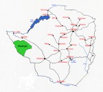
Photo: Bart Wursten
Map showing location of Hwange National Park
General Information
Quarter degree square: many Country: Zimbabwe Habitat: Kalahari sand forest, Acacia savanna, mopane woodland, seasonal pans, rocky outcrops ao. Altitude range: c. 950 - 1100m Annual rainfall: Location (short): Southwestern Zimbabwe, bordering on Botswana. Largest National Park in the country. Location (detailed): This is the largest National Park in the country park covering an area of about 14,650 km² in Hwange district, Matabeleland North, bordering on Botswana in the Southwest. The park is managed by the Zimbabwean Department of National Parks and Wildlife Management. |
Description
Useful links
View a list of records for Hwange National Park
View a list of unique taxa (excluding cultivated plants) for Hwange National Park
View a list of unique taxa (all taxa whether cultivated or not) for Hwange National Park