Location: Great Zimbabwe
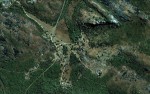
Photo: Google Earth
Map Great Zimbabwe National Monument.
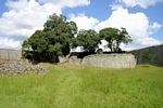
Photo: Michael Jackson
View of Mimusops zeyheri trees within the Great Enclosure, Great Zimbabwe
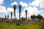
Photo: Bart Wursten
Spectacular specimens of Aloe excelsa and Euphorbia ingens abound among the ruins.
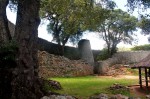
Photo: Bart Wursten
The Conical Tower in the Great Enclosure flanked by ancient specimens of Mimusops zeyheri.
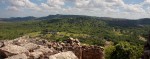
Photo: Bart Wursten
Panorama of the Valley Complex as seen from the Hill Complex

Photo: Bart Wursten
Great Enclosure as seen from the Hill Complex
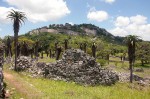
Photo: Bart Wursten
Hill Complex seen from near Great Enclosure.
General Information
Quarter degree square: 2030B4 Country: Zimbabwe Habitat: High rainfall, rocky areas and woodland Altitude range: 1100 - 1200 m Annual rainfall: Location (short): Location (detailed): |
Description
The ruins of Great Zimbabwe bear a unique testimony to the lost civilization of the Shona between the 11th and 15th centuries. A unique artistic achievement, this great city has struck the imagination of African and European travellers since the Middle Ages, as evidenced by the persistent legends which attribute to it a biblical origin. The entire Zimbabwe nation has identified with this historically symbolic ensemble and has adopted as its emblem the steatite bird, which may have been a royal totem.
The impressive ruins of Great Zimbabwe ('stone houses', which cover an area of some 80 ha, lie 30 km from Masvingo (formerly Fort Victoria).
The site is a National Monument and was declared a World Heritage site by UNESCO in 1986.
The pioneering works of David Randall-MacIver in 1905-6, corroborated since by numerous finds of dated archaeological artefacts and by radiocarbon analysis, have proved that Great Zimbabwe was founded in the 11th century on a site which had been sparsely inhabited in the prehistoric period, by a Bantu population of the Iron Age, the Shona. In the 14th century, it was the principal city of a major state extending over the gold-rich plateaux; its population exceeded 10,000 inhabitants. In about 1450, this capital was abandoned, not as a result of war, but because the hinterland could no longer furnish food for the overpopulated city, and deforestation made it necessary to go farther and farther to find firewood. The resulting migration benefited Khami, which became the most influential city in the region, but signalled waning political power.
When in 1505 the Portuguese settled in Sofala, the region was divided between the rival powers of the kingdoms of Torwa and Mwene-Mutapa. From the 11th to 15th centuries, the wealth of Great Zimbabwe was associated with gold trading, controlled by the Arabs, and extensive trade activities on the east coast of Africa where Kilwa was the main trading centre. In addition to jewellery that had escaped greedy European gold hunters at the end of the 19th century, archaeological excavations in Great Zimbabwe unearthed glass beads and fragments of porcelain and pottery of Chinese and Persian origin which testify to the extent of trade within the continent. A 14th-century Arab coin from Kilwa was also found; it was reissued in 1972.
The territory managed by the National Museums and Monuments Administration includes the three main areas of Great Zimbabwe :
- The Hill Ruins, forming a huge granite mass atop a spur facing north-east/south-west, were continuously inhabited from the 11th to 15th centuries, and there are numerous layers of traces of human settlements. This acropolis is generally considered a 'royal city'; the west enclosure is thought to have been the residence of successive chiefs and the east enclosure, where six steatite upright posts topped with birds were found, considered to serve a ritual purpose.
- The Great Enclosure below the hill to the south dates from the 14th century. In the form of an ellipsis, it is marked off by a wall of cut granite blocks laid in regular courses. Inside the Great Enclosure, a series of living quarters in brick have been noted. The brick (daga) was made from a mixture of granitic sand and clay. Huts were built within the stone enclosure walls. Inside each community area other walls mark off each family's area, generally comprising a kitchen, two living huts and a court.
- The Valley Ruins are a series of living ensembles scattered throughout the valley. Each ensemble has similar characteristics: many constructions are in brick (huts, indoor flooring and benches, holders for recipients, basins, etc.) and drystone masonry walls provide insulation for each ensemble. Finds made in the inhabited areas and the dumping ground have furnished precise information about the farming and pastoral activities of the inhabitants at the time of Great Zimbabwe's heyday and about earthenware and smiting craft activities.
Useful links
View a list of records for Great Zimbabwe
View a list of unique taxa (excluding cultivated plants) for Great Zimbabwe
View a list of unique taxa (all taxa whether cultivated or not) for Great Zimbabwe